
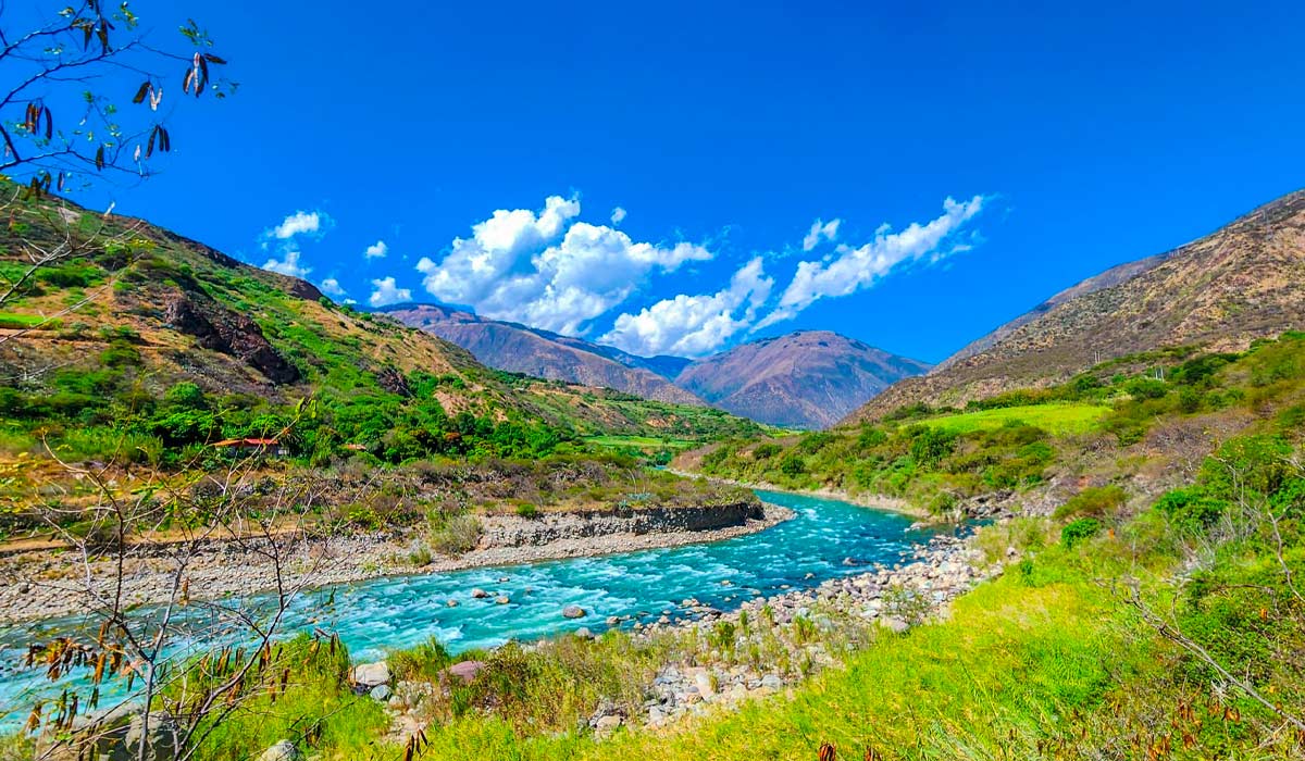
The Apurímac River is one of the most important hydrographic axes in southern Peru, known for its deep canyons and its flow. The word "Apurímac" comes from Quechua and is translated as "The Gentleman Who Speaks" or "Lord Who Speaks," reflecting the reverence that Andean cultures had for it. This river is born from the melting snow of Nevado Mismi, in the Arequipa region, and flows from south to north until it helps form the Amazon. Due to its size and archaeological value, it is considered one of the best destinations in Peru for adventure tourism.
The Apurímac River canyon, which marks the natural border between the departments of Cusco and Apurímac, is the most famous section of the route. Geographically, it is an area of landscapes of Peru that are dramatic and challenging, with vertical cliffs that are over 2,000 meters deep. Its beauty hides a rich history: chronicles of the conquest mention the existence of an Inca temple and oracle near its waters, which highlights the ritual importance of the Apurimac in the Andean worldview.
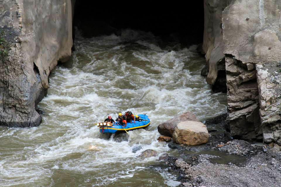
Today, the Apurimac River is world-renowned for being a white-water destination, offering Class IV and V rapids that attract expedition rafting enthusiasts. This guide is designed to explore the Apurimac Valley, detailing the history, climate, and, mainly, the logistics needed to undertake a safe and organized adventure on this challenging river.

About the Apurímac Valley
The Apurimac Valley is a large and rugged territory of approximately 260 kilometers in length, marked by extreme geography in the Southern Highlands of Peru. The altitude of the inhabited territory reaches a maximum of 3,600 masl, while the floor of the canyon drops to less than 1,400 masl. This setup creates a diversity of climates that range from the cold puna (high grassland) to the forested highlands. The mountains that surround the valley, such as the Vilcaconga mountain range, often exceed 4,000 masl.
The topography is extremely difficult and the valley is narrow, which historically made it unsuitable for large population settlements. For this reason, the Apurimac Valley Peru was mainly used as an escape route, a temporary refuge, and a strategic zone for the movement of troops and hikers. Access to the bottom of the canyon is complex, with trails formed by the drainage of lakes that become steep slopes and waterfalls over the river.
Where is the Apurímac Valley located?
The Apurimac Valley is located in the Southern Highlands of Peru, and acts as the natural border between two departments: Cusco (on its left bank) and Apurímac (on its right bank). Geographically, it covers a wide territory that begins at the source of the Apurímac River, near the Mismi Snowy Peak (Arequipa), and extends north. The most visited canyon area, used for trekking and adventure sports (like rafting), is located near the districts of Curahuasi (Apurímac) and Mollepata (Cusco).
Tourism in the Valley of Apurimac
The Apurímac department as a tourist destination in Peru, has as its maximum exponent the Apurimac River, ideal for the practice of Canoeing in Peru, it presents an abrupt geography, formed by narrow and deep valleys, with impressive chasms, cold plateaus and high peaks. The Grand Canyon of the valley of Apurimac stands out, which marks the limit with the department of Cusco.
Abancay, capital of Apurímac, is a beautiful colonial-style city protected by the imposing snow-capped Ampay (5235 masl), located in the national sanctuary of the same name. The sanctuary houses, in addition to other snow-capped mountains, mountain forests, beautiful lagoons and species of flora and fauna such as the intimpa, the Andean fox and the taruca.
The inhabitants of the department are mainly engaged in agriculture and are descendants of various groups that were characterized by their warrior spirit. The area was the subject of bloody clashes between two enemy towns, the Chancas and the Incas.
From Abancay numerous excursions can be made; such as the Saywite archaeological complex; and the imposing Valley and Canyon of the Apurímac River, paradise for canoeing and hiking.
Another important city of Apurímac is Andahuaylas, a typical Andean city, with a Plaza de Armas and narrow valleys.
Apurimac River in Perú
The Apurimac River in Perú is one of the main rivers of Peru, it is part of the main course of the Amazon River, it has its origin in the Andes mountain range and it is the dividing line between the departments of Cuzco and Ayacucho. It is excellent for boating and sport fishing.
-
Origin of his name
The name of Apurímac merits its wealth, which in the Quechua Inca language is Apu - Rimac (Talking God). Apu, in Quechua, means "sir." The Apu Rimac is the "Oracle or Great Talker", considered to be the most powerful of the Inca oracles, who spoke through the tremendous rapids of the river. -
Geography
The Apurimac River in Perú is one of the main rivers of Peru, which constitutes the upper part of the Ucayali River course, and part of the main course of the Amazon River.
Peru is undoubtedly a varied and privileged country and has 85% of the world's microclimates and therefore a similar percentage of all the world's flora and fauna, the Andean highlands, the melting of the mountain chain of the Andes, provoke the formation of lakes, lagoons and rivers throughout the Peruvian highlands, which generates an excellent habitat for the development of the three varieties of trout in Peru: the golden trout, the rainbow trout, and the brown trout and the sardines and fish that our ancestors, the Incas assumed and still here in Cuzco - Peru, it is found in some rivers called Jahuaco fish, which have caught fish (trout) weighing from 2 to 10 kls . In the spining (butterfly) and fly fishing lagoons, however, it is possible to find specimens weighing 500 gr. At 2 kg. Almost in all the mountain rivers, but in some rivers there are still good specimens such as the Apurimac River, fishing is recommended between the months, from May to October, especially with butterflies using the numbers from 1 to 3. -
Origin of the Apurimac River in Perú
The Apurimac River in Perú has its origin in the Andes mountain range, in the Nevado Mismi mountain (5597 m), between Cuzco and Arequipa, 650 kilometers southeast of Lima and 160 km west of the Lake Titicaca basin, being the most distant from the Amazon basin. -
Course of the Apurimac River in Peru
The Apurimac River in Perú flows to the northwest, running through the Cuzco and Ayacucho regions constituting the dividing line between these two departments, on the right bank is the province of La Convencion and on the left bank, the provinces of La Mar and Huanta.
In its course it is distinguished, the Alto Apurímac of torrential waters and relatively narrow cause, which runs from the source to the confluence with the Pampas. And then the Bajo Apurímac, with calm waters and a wide channel, until its confluence with the Mantaro (at 430 meters above sea level) from this point receives the name of Ene, a point that marks the triple confluence between the regions of Junín, Ayacucho and Cuzco.
Further down, the Jan, having received the waters of the Urubamba River on the right, becomes the Ucayali River. For much of its 700 km route, it flows through narrow canyons and its path is interrupted by waterfalls and rapids. -
Tributaries
The Apurimac River in Perú receives many tributaries that are named after the hamlets or arable land that they cross. The Apurímac route runs from south to north. -
History of Apurimac River in Perú
Apurímac is the river that "speaks as lord", whose sources are found in the Villafro and Huarahuarco lagoons, in the heights of the Vilcanota mountain range, identified by some geographers as the most remote origin of the Apurímac. The vast region crossed by the Apurímac River is of extraordinary historical wealth and formerly they gave this river the name of Cápac Mayu for saying that it was the prince of all the rivers in the world (Garcilaso).
Sport in Apurimac River in Perú
-
Rafting
The Apurimac River in Perú is one of the best rivers in the world for canoeing, as it has the right conditions for practicing this sport: excellent weather, rapids and beautiful sandy beaches for camping. -
Excellent place for sport fishing
For lovers of sport fishing, nature and adventure, the Apurimac River is the price place.
In this beautiful river you can fish for the night fish "Jahuaco", this fish is only fished at night, as well as other species such as trout and sardines. You will also enjoy the excellent panorama, flora and fauna that are in the place. -
Trekking in Apurimac Valley
Choquequirao (sometimes also as Choqequirau or Choquekiraw) is known as the "sacred sister" of Machu Picchu for the structural and architectural resemblance to it. The most famous routes are: Choquequirao Trek 4 Days, the Choquequirao Trek 5 Days or the Choquequirao to Machu Picchu Trek.
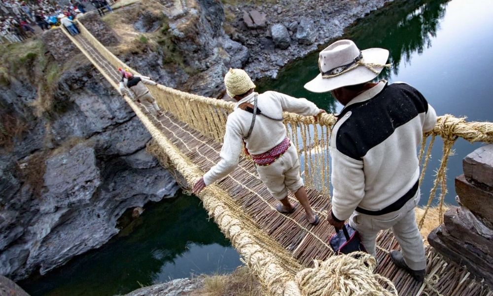
Did you know there is an Inca bridge over the Apurímac River?
The Q'eswachaka Bridge is the last Inca hanging bridge that is kept and renewed yearly. Located over the Apurímac River, in the district of Quehue (Cusco region), this spectacular Andean engineering work is approximately 28 meters long and 1.20 meters wide. UNESCO recognized this ancestral practice as Intangible Cultural Heritage of Humanity in 2013.
The Annual Renewal Ritual
The renewal of Q'eswachaka is a four-day traditional festival that involves around 1,000 residents from four Quechua communities (Hunchiri, Chaupibanda, Choccayhua, and Ccollana Quehue). The ritual follows a strict schedule:
- Day 1 | Fiber Preparation: The residents collect and braid the main raw material, the qoya ichu (vegetable fiber), to create the small ropes (queswas). This day an offering (payment to the earth) is made to the guardian apu Quinsallallawi, asking for its protection.
- Day 2 | Dismantling and Major Braiding: The old bridge from the previous year is taken apart. The men gather on the banks to stretch out the new small ropes, which are then assembled by the chakaruhac (the Inca engineer in charge of the bridge) to form the base ropes (qeswaska).
- Day 3 | Assembly and Structure: The base ropes and the two handrail ropes are launched and fixed to the stone nails. This day ends with the assembly of the bridge's surface, leaving it ready for use.
- Day 4 | Opening and Celebration: The final day celebrates the successful completion of the assembly. The bridge is opened with a festival of indigenous dances and music, organized by the four communities, which marks the return of the bridge to its vital function.
How to get to the Apurimac River bridge?
The Quehue district is located 180 kilometers from the city of Cusco. There is a paved road that reaches the Inca bridge itself.
To get to the place where the festival will take place, you can board the vehicles of the local transport service. The first section leaves the city of Cusco and reaches the town of Combapata, the second section from Combapata to Yanaoca; and lastly, from Yanaoca to the Quehue community (this last section does not have public transport service and they have to contract a local private service).
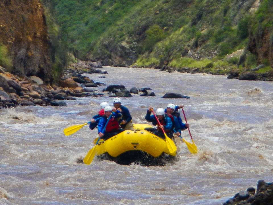
Apurimac Rafting: White-water river tours
The best destination to do rafting white-water river in Peru is the Apurimac river, below you can choose the best option trip for you!
- Apurimac River rafting (3 days/ 2 nights)
- Adventure Holidays Peru (12 days/ 11 nights)
Alternative trips to the Apurimac Rafting
- Urubamba river rafting (2 days/ 1 night)
- Cusco Rafting day tour
- Inca Jungle Trek (4 days/ 3 nights - Biking, Rafting, Walking and Zip Line)
- Inka Jungle Trek (3 days/ 2 nights - Biking, Rafting and Zip line)
In these activities, you can add the best destination of Peru: The lost city of the Incas - Machu Picchu.
Discover Machu Picchu by foot to the Inca Trail tours or alternative hike 2, 3, 4, or 7 days or also you could do the Machu Picchu tours from Cusco.
- Short Inca Trail (2 days/ 1 nights)
- Inca Trail to Machu Picchu(3 days/ 2 nights)


