Choquequirao to Machu Picchu Trek
Choquequirao to Machu Picchu trek 9 days offering to hike the two most impressive Inca cities: Choquequirao and Machu Picchu! During Machu Picchu trek find
Description
This is the only trek that offers you to hike the two most impressive Incan cities: Choquequirao and Machu Picchu! However, both show off the same high Incas architecture quality, the Inca City of Machu Picchu receives thousands of tourists every day while Choquequirao Archeological Park receives only a couple of visitors due to its location on top of the Vilcabamba mountain range in the district of Santa Teresa province of the Convention at 3,033 m.a.s.l (9959 ft). Although, it is definitely worth visiting as it offers not only views of this enigmatic and fantastic Inca's site, but also the possibility of seeing the condors in majestic flight, pumas, quetzals, foxes, hummingbirds, skunks, deer or Tarucas, bears of glasses and the famous National bird of Peru the "Gallito de las Rocas". Even more, for vegetation lovers there is a wide variety of orchids such as diverse vegetation and local crops such as coca, cocoa, corn, coffee and abundant fruit trees.
Condors soaring in the quiet atmosphere of mountains! This unique trek continues exploring very historic Andean towns and a daily life of their residents, beautiful mountains and rivers until you reach the City of Choquequirao where you will see buildings of temples, prisons and government buildings, beautiful mozaicos of ‘llas’, separated into 9 different sections that include the temple, squares known as Hanan and Hurin (Alta and Baja) and the main square Huaqaypata. Choquequirao also has a ceremonial platform called Ushno, this whole complex has a great similarity with Machu Picchu showing in both parts its buildings and agricultural terraces along the slope of the mountain.
Did you know that the word Choquequirao means the “Cradle of the Gold” in southern Quechua? But it is also known by other names such as "City of the heathen", "Refuge of the Incas", "City - or town - of the silver smith" and "Last refuge of the Incas of Vilcabamba".
Choquequirao is considered as one of the last resistance bastions and refugees of the Incas, who abandoned the imperial city of Cusco in 1535 by order of the Incan ruler Manco Inca to regroup because Cusco was besieged by Spaniards. Don't forget to bring your photography equipment with you because this journey is the most picturesque trip offered in the Cusco’s area! There's going to be horses along the trip for your convenience and we provide you with top quality camping equipment as well as a very balanced and energetic diet. Are you waiting for an unforgettable adventure? The Combo Expedition connecting both Incan highlights, Machu Picchu and Choquequirao will go beyond your dreams!! So, are you ready? Discover the beautifull Machu Picchu and its sister Choquequirao with us!
What to Expect
Is this tour for you?
Sustainable Tourism
At Tierras Vivas, we are happy to promote and practice sustainable tourism by being eco-friendly and supporting local communities.
Activity: Trekking/Hiking, Cultural, Natural and History
9 Day hike to Machu Picchu, you will view the beautiful mountains andlandscapes of Choquequirao and Machu Picchu.
Service Level: Confort
Comfortable personal camping equipment: Sleeping bag, air mattress, air pillow, blanket, hiking poles, emergency horses and private transport.
Physical Rating: 4 - Demanding
Some are high-altitude hikes or more strenuous activities, but accessible to most healthy travellers.
Crew: A Tierras Vivas Representative, professional guide, cook and muleteer for the trek.
Tierras Vivas representative will be visiting your hotel for your information, the guide accompanying during the hike from Choquequirao to Machu Picchu. Our cook and muleteer will walk 7 day with you group.
Accommodation: 8x campsite.
Our tents are of the brand MOUNTAIN PASS 3XTE designed for any of the 4 seasons. We provide with 3 person capacity tents; however, just 2 trek participants use it!
Local Tour Operator: Tierras Vivas 100% Peru Local Operator
Tierras Vivas is an recognized tour operator and specialist in hiking/trekking since 2006.
Meals: 8x breakfast, 8x lunch, 8x dinner, 6x afternoon tea.
Vegetarian, vegan or special menus are available without any extra cost. (You should bring USD 20 - 30 for meals not included).
Transportation: Transportation by private van, 1x train (Expedition Service).
Please note: If you want short hike to Choquequirao, we recommend the Choquequirao Trekking 5 days Tour
Quick Itinerary
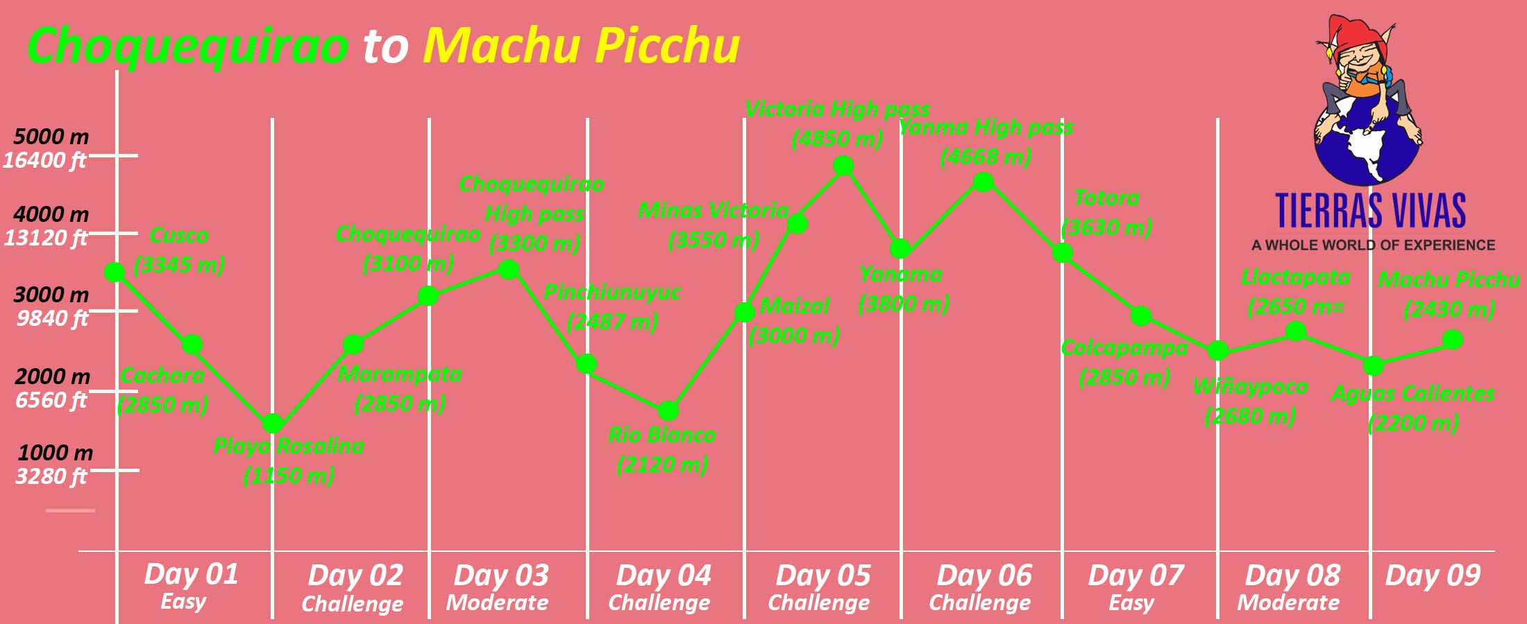
Day 01: Cusco - Cachora - Playa Rosalina
Day 02: Playa Rosalina - Marampata - Choquequirao
Day 03: Choquequirao - Maizal
Day 04: Maizal - Minas Victoria - Yanama
Day 05: Yanama - Totora
Day 06: Totora - Collpapampa - Wiñaypoco
Day 07: Wiñaypoco - La Playa - Lucmabamba
Day 08: Lucmabamba - Hidrolectrica - Aguas Calientes
Day 09: Aguas Calientes - Machu Picchu - Aguas Calientes - Cusco
Highlights of the Choquequirao to Machu Picchu Trek:
- Visit of the biggest cities of the Incas in only one tour.
- Discover and enjoy a guided tour of the last Incan refuge - Choquequirao, hidden in jungle.
- Visit of the "Lost City of the Incas" - Machu Picchu
- Following an authentical Inca's path
- 9 day hike with a professional Tour Guide, cooks, horsemen and horses
- Observation of Cusco's highlands and a high jungle as well
- Visit of very remote Andean villages where most of tourists do not have chance to go
- Exploration of old Incan mines
- Spectacular landscape views
How difficult is the trek from Choquequirao to Machu Picchu?
Choquequirao Tips
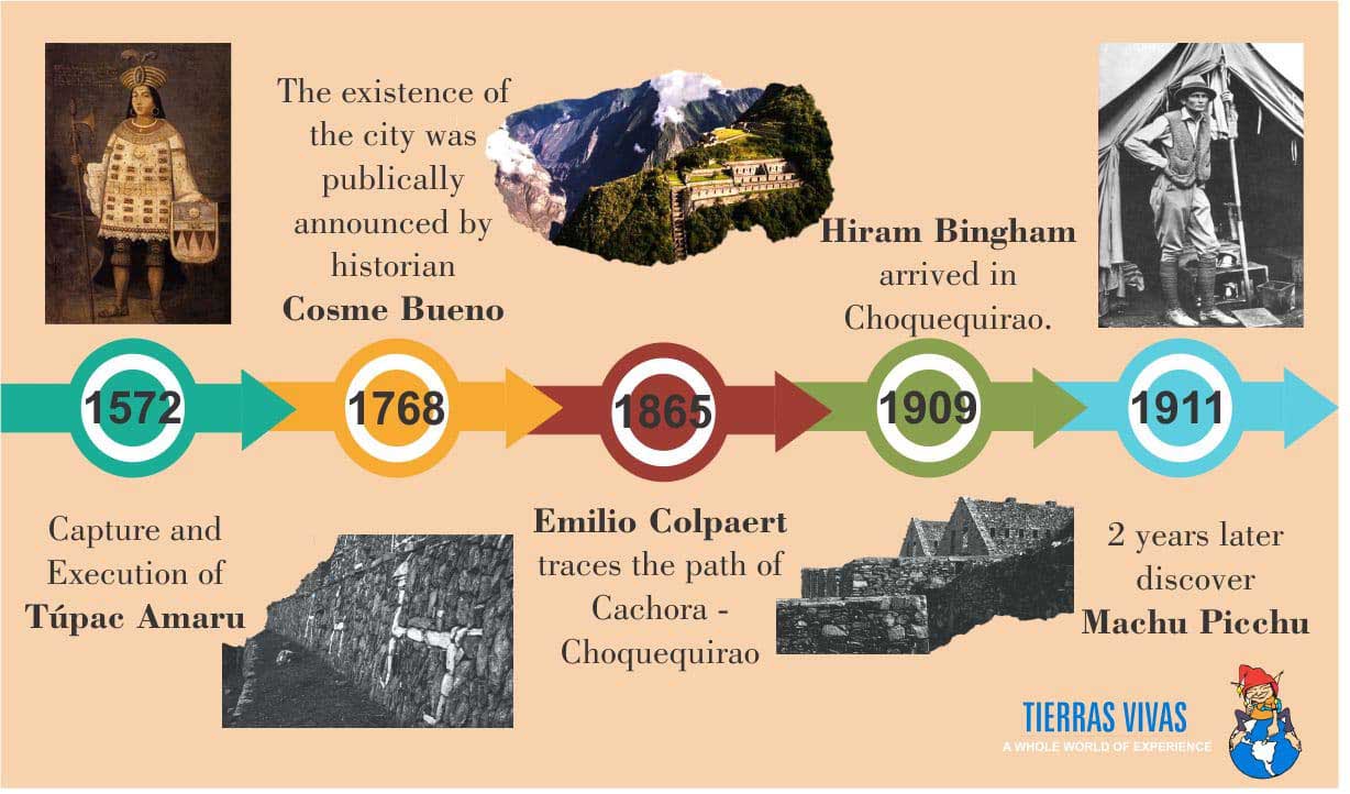
Most Relevant Chronological Data in the History of Choquequirao
Responsible Travel
If you want to know about our foundation, please click Responsible Travel with Tierras Vivas tour operator.
Tierras Vivas - Family Porters
Tierras Vivas DOES NOT permit this exploitation!! We guarantee that our porters carry only an amount given by the Peruvian law!! There is still a long way to go when it comes to a reserve of adequate meals, backpacks and warm dry sleeping accommodation. click here
Each Year Tierras Vivas celebrate a Christmas party in Patacancha. Family porters,
Itinerary Details
Day 01: Cusco - Cachora - Playa Rosalina
We leave Cusco early in the morning by private vehicle. After 4 hours, we reach Cachora (2,850 m/9,350 ft), a small village and the starting point of this hike. We start descending to the Apurimac River Valley having incredible views of far away snowy peaks. We have first opportunity to see Choquequirao Mountain on the opposite site of the valley after a couple of hours of walking. The way to Choquequirao leads through a highland jungle (or Andean jungle) so the weather is warm, humid and rainy resulting in a very rich tropical vegetation and fauna too. Of the vegetation, we can see native trees such as lambram, chachacomo and inkallaulli. There are also cedars, medicinal plants, ferns, orchids, bromelias, etc. Representans of local fauna are deer, a spectacled bear, felines, foxes, skunks, birds such as a variety of of hummingbird species or Andean condors crisscrossing the sky in the afternoons. In the end, we reach our first campsite at Playa Rosalina (1,550 masl/5,115 ft) located at the shores of the Apurimac River.
- Estimated trekking time: 7-8 hours
- Trekking distance: 19 km
- Max. elevation: 2,850 m (9,350 ft)
- Min. elevation: 1,550 m (5,115 ft)
- Climate: Warm
- Difficulty: Easy
Day 02: Playa Rosalina- Marampata - Choquequirao
After a nutritive breakfast, we start a gradual ascend to Marampata (2,850 m/9,350 ft), the trek gets harder but remember every effort will have its reward; however, it offers spectacular views of the deep Apurimac River Canyon and the river itself that is the main tributary of the Amazon River! We can also spot condors soaring in the mountains! When we get to Marampata, we have lunch there and a short rest. At around 4 pm, we will arrive to the enigmatic and fabulous Cradel of Gold - Choquequirao (3,100 m./10,168 ft)! The city is considered bigger in extension than the Sancturary of Machu Picchu! Our Tour Guide shows us around the city and explains us about its each part such as Hauqaypata (main square) with the principal Sun Temple, Urin (upper square) with its open temple, Ushno (ceremonial platform), houses of priests, qolqas (storages), irrigation channels and agricultural terraces. However, investigation works have not discovered all the site yet so we can still expect more surprising excavations in future!! From there, we also can view spectacular mountain scenery surrounded by the cloud forest! We set a camp near the archaeological site and overnight.
The Archaeological Park of Choquequirao is situated in southern Peru on the right side of Apurimac River, at the slopes of the same named mountain just next to Qoriwayrachina Mountain of the Salkantay Mountain Range where the impousing Salkantay glacier is located . The park covers an area of 1,810 hectares.
Choquequirao was constructed probably between the second part of the 15th century and the first decades of the 16th century, it means the period when Incas started to conquer new territories of Antisuyo (located northwest of Cusco in high Andes inhabited by so called “Antis” – a collective name for the many varied ethnic groups living in this area). Choquequirao is considered as one of the last resistance bastions and refugees of the Incas, who abandoned Cusco in 1535 by order of the Incan ruler Manco Inca to regroup as Cusco was besieged by Spaniards.
- Estimated trekking time: 6 hours
- Trekking distance: 11 km
- Max. elevation: 3,100 m (10,168 ft)
- Min. elevation: 2,850 m (9,350 ft)
- Climate: Warm as well as cold
- Difficulty: Moderate
Day 03: Choquequirao - Maizal
After a delicious breakfast, we will leave the Incan city of Choquequirao to first gently hike for 3 hours up to the Choquequirao Pass (3,300 m/10,890 ft) to then start descending to Rio Blanco (White River; 1,900 m/6,270 ft) to enter at the cloud forest. There, we can appreciate polylepis trees (native mountain trees with shredded, multi-layered bark), epiphytes, bromeliads, orchids, diverse bird species as well as water fountains. Lush vegetation of the cloud forest still cover a part of the Inca farming terraces of Pinchiunuyoc (2,487 m/8,160 ft). After our Tour Guide explains us about this Inca site, we keep descending passing through coca plantations and gradually changing nature into a dry Andean forest. After having lunch there, we will climb for another three hours towards the village of Maizal (3,000 m/9,900 ft) where we set up our next campsite. From this natural view point, we can appreciate imposing views of the gorges of Yanama and Yurahmayo that later join the Apurimac River Canyon! Also the sunsets there are really stunning!
- Estimated trekking time: 6 hours
- Trekking distance: 5 km
- Max. elevation: 3,300 m (10,890 ft)
- Min. elevation: 1,900 m (6,270 ft)
- Climate: Warm with mosquitoes
- Difficulty: Moderate
Day 04: Maizal - Minas Victoria - Yanama
We start ascending after early breakfast towards the Victoria Pass (4,150 m/13,695 ft). After a 4 hour steep ascend, we reach the Minas Victoria, an Incan and later colonial silver mining centre that is abandoned nowadays. Then, we hike along a hill called Qoriwayrachina, a place where archaeological explorations have been done recently. Closer to the Victoria Pass, we start following an incredibly well- preserved authentical Inca trail with stone steps in its middle! When we reach the Victoria Pass, we enjoy a breathtaking view of the snow-capped mountains of Humantay (5,700 m/18,700 ft) and snowy Salkantay (6,271 m/20,574 ft), considered by local people as the "guardian spirit of the jungle"! Finally, we descend to the village of Yanama (3,800 m/12,540 ft) where we overnight in another campsite with views of the Yanama River below us and Pumasillo Mountain above us.
- Estimated trekking time: 7 hours
- Trekking distance: 10 km
- Max. elevation: 4,150 m (13,695 ft)
- Min. elevation: 3,800 m (12,540 ft)
- Climate: Warm with mosquitoes as well as cold
- Difficulty: Moderate-Difficult
Day 05: Yanama - Totora
We start hiking in the morning towards the Yanama Valley passing farmar´s fields and lush vegetation to later overcome the highest pass of the trek - Yanama Pass (4,668 m/15,315 ft). This causes that today´s trek gets harder and the day is challenging! However, it offers spectacular views of a chain of snowy peaks such as the Sacsarayoj and Padreyoc Mountains! If we are lucky, we can also spot majestic condors flying above surrounding cliffs. When reaching the pass, we are able to observe a pile of stones that have been added by visitors to thank to Apus (a mountain god) for a safe journey and good luck! Then, we descend to the Totora Pampa where our next campsite is situated near the village of Totora (3,630 m/11,979 ft).
- Estimated trekking time: 8 hours
- Trekking distance: 10 km
- Max. elevation: 4,668 m (15,315 ft)
- Min. elevation: 3,630 m (11,979 ft)
- Climate: Warm with mosquitoes
- Difficulty: Challenging
Day 06: Totora - Collpapampa - Winaypoco
We start trekking today following the flow of the Totora River to later descend gradually to a high (or mountain) jungle - known in Spanish as the "Ceja de selva (literally: jungle´s eyebrow) so we can notice the quickly changing vegetation and temperature getting warmer. In the high jungle, we can view its typical lush vegetation of wild orchids and bromeliads as well as watch a variety of beautiful birds. Then, we descend to bamboo groves. Do not forget to look back sometimes as you can see snow-peaks framed by bamboo fronds behind you! We pass through the village of Luscamayo and after a 4 hour descend; we reach a tiny settlement of Collpapampa (2,850 m/9,348 ft), a place of our lunch break. Afterwards, we keep descending having the Santa Teresa River on the left side observing small coffee and tropical fruit´s plantations on the way. In the end, we get to the foothill of the Wiñaypoco Mountain where we set a campsite (2,680 m/8,793 ft).
- Estimated trekking time: 6-7 hours
- Trekking distance: 10 km
- Max. elevation: 2,850 m (9,348 ft)
- Min. elevation: 2,680 m (8,793 ft)
- Climate: Warm with mosquitoes
- Difficulty: Moderate
Day 07: Winaypoco - La Playa - Lucmabamba
After a healthy breakfast, the trail continues down towards the Aobamba River passing through bamboo groves, orchards and coffee plantations providing some perfect birdwatching opportunities (e.g. hummingbirds, woodpeckers). We walk on some fantastic untouched paths where strawberries grow at our feet and passion fruits are just above our heads, this all decorated with begonia and purple orchid rugs! After 2 and half an hour, we arrive to a tiny place called La Playa (2,100 m/6,890 ft) where we have a small break accompanied by lunch with fresh fruits! Later, we keep trekking until we get to the village of Lucmabamba (2,250 m/7,381.89 ft), a place of our next overnight. This is another easy trekking day, during which we enjoy observation of lush vegetation as well as we get familiar with diverse plants cultivated in this area such as banana, avocado, coca leaf, coffee, etc. The areas is also a habitat of a spectacled bear and many parrots.
- Estimated trekking time: 6 hours
- Trekking distance: 5 km
- Max. elevation: 2,250 m (7,382 ft)
- Min. elevation: 2,100 m (6,890 ft)
- Climate: Warm with mosquitoes
- Difficulty: Easy
Day 08: Lucmabamba-Hidroelectrica-Aguas Calientes
We wake up early today to start a nice up-hill walk providing us some amazing views of the valley. After a 5 hour hike, we enjoy our last lunch at the recently restored Incan ruins of Llaqtapata (2,650 m/8,694 ft) from where we can view both, Machu Picchu and the Salkantay Mountain! Then our Tour Guide shows us around the ruins! From there, we are given an opportunity to see the main highlight of South America - Machu Picchu, from an exceptional point of view that a majority of tourists will never see!! Then, we descend easily for 3 hours to the Hydroelectric Plant (Hidroelectrica; 2,050 m/6,726 ft). There, we follow trails and the Vilcanota River leading us to Aguas Calientes (2,042 m/6,700 ft), located at the foothill of Machu Picchu Citadel! We will sleep in a confortable hotel and get ready to visit Machu Picchu on next day.
- Estimated trekking time: 10 hours
- Trekking distance: km
- Max. elevation: 2,650 m (8,694 ft)
- Min. elevation: 2,042 m (6,700 ft)
- Climate: Warm with mosquitoes
- Difficulty: Moderate-Difficult
Day 09: Aguas Calientes - Machu Picchu - Aguas Calientes - Cusco
After an early morning breakfast, we take a bus up to the mysterious city of Machu Picchu (2,430 m/7,972 ft) that we enter for the early morning best photos opportunities! After that, our tour guide will show us the Inca city and explain its history and purpose on a 2-hour tour. After the guided tour, we have the option to climb Huayna Picchu for about 45 minutes, or to the peak above Machu Picchu to take some panoramic photos of the Inca city (this alternative requires a prior reservation).
Machu Picchu is both, the best and the least known site of the Incas as it is not mentioned in any Spanish conquistador´s chronicle so that contemporary archaeologists can not do anything more than just speculate on its functions. Local Quechua farmers had known about Machu Picchu for centuries before an 11 year old boy showed the American historian Hiram Bingham (who was in a search of Vilcabamba) on the 24th of July, 1911. At that time, all the rest of the world became aware of its existence. However, the site was covered with thick vegetation so Hiram Bingham along with his team returned and within the years of 1912 and 1915 cleared its surface. Over the years, plenty of work has been done on excavating and studying the site. Despite these efforts, many unanswered questions remain.
In the afternoon, we come back to Aguas Calientes and return by train to Ollantaytambo (alternatively to Poroy), from where we are taken by van back to Cusco.
- Estimated trekking time: 1 hour
- Trekking distance: 3 km
- Max. elevation: 2,430 m (7,972 ft)
- Min. elevation: 2,042 m (6,700 ft)
- Climate: Warm
- Difficulty: Moderate
Included
What is included in this trek?
- Pre-trek briefing (Our guide will be meeting in your hotel/Airbnb for your breifing);
- Early morning transfer by private bus to the initial point of the trek (Punta Carretera);
- Accommodation: Campsites (7 nights); Hotel in Aguas Calientes (1 night)
- Entrance fee to Choquequirao and Machu Picchu;
- Meals: 8x breakfast, 8x lunch, 7x dinner and 7x afternoon hot beverages;
- Snack every morning;
- Professional bilingual Tour Guide;
- Trekking Professional Chef;
- Horseman;
- Horses to carry food, camping and cooking equipment and 7 kg of each passenger's stuff;
- Water every day (excluding the first 4 hours of the trek when you need to bring your own);
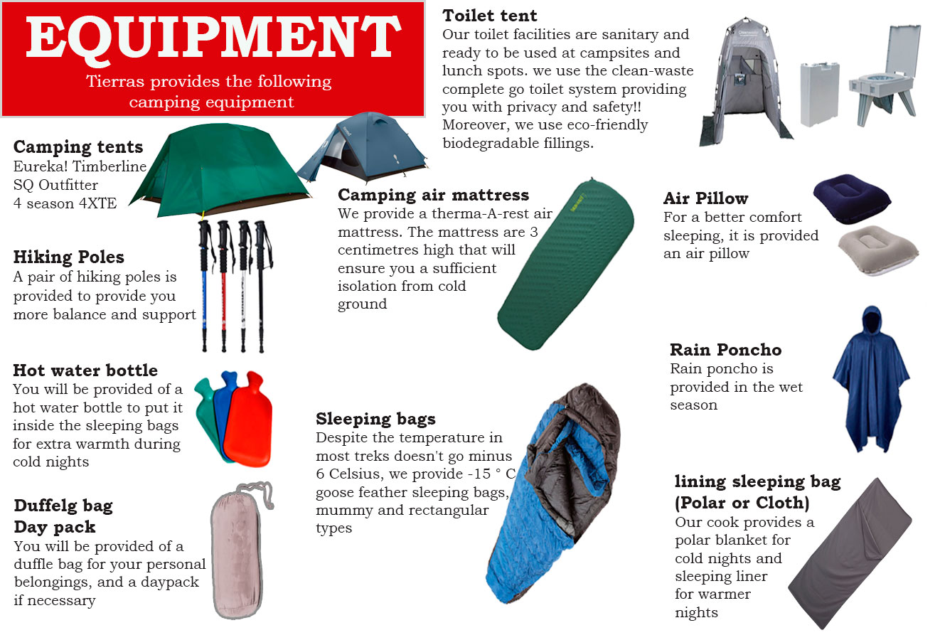
- Camping equipment: Eureka Mountain double tents, tables and chairs, a cooking tent with cooking equipment, dining and toilet tents and bottled gas;
- Sleeping air mattress (Term-a-rest mattress)
- A sleeping bag (for up to -5°C);
- A Blanket;
- A air Pillow;
- A pair of hiking poles;
- Tables and chairs, a cooking tent with cooking equipment, dining and toilet tents and bottled gas;
- Rain Ponchos;
- Duffel bag (for your personal belongings);
- A T-shirt of the Salkantay Trek Map;
- Food;
- Tourist train from Aguas Calientes (Machu Picchu) to Ollantaytambo;
- Tourist bus from Ollantaytambo to Cusco.
Camping equipment provide for Choquequirao to Machu Picchu
Not Included:
- Breakfast on the day 1 and lunch on the last day;
- International and domestic flights nor airport departure taxes;
- Travel Insurance
- Entrance fee to Huayna Picchu ($80);
- A shuttle bus between Machu Picchu and Aguas Calientes Town ($12- one way, $24 - a round trip);
- Tips to local staff (please note: it is a custom to give tips in Peru; however, it is not obligatory);
- Other extras not mentioned.
Solo Traveler: Please note that if you have booked the "Solo Traveler" option for this trek, you receive your own single tent for all nights.
Local flights: No local flights are included in the trek's price!
Essential Information
Starting point & Pick up
Usually our hike is starting from Cusco, but we can pick you up from your hotel outside of Cusco. Please check your trip and location for pick you up.
| Trip/ Hiking |
Starting point & pick up |
| Inca Trail |
Cusco, Chinchero, Urubamba, Yanahuara, Ollantaytambo |
| Salkantay Trek |
Cusco |
| Lares Trek |
Cusco, Pisac |
| Rainbow Mountain |
Cusco |
| Ausagante Trek |
Cusco |
| Choquequirao trek |
Cusco |
| Inca Jungle Trek to Machu Picchu |
Cusco, Urubamba, Yanahuara, Ollantaytambo |
| Inca Quarry Trail |
Cusco, Urubambam Yanahuara |
| Day tours |
Only Cusco |
Appropriate clothing along this hike
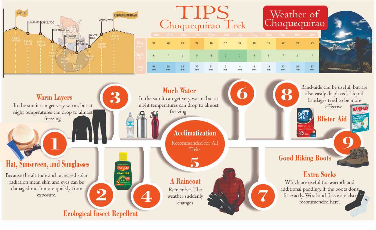
Hiking pants and T-shirts are recommended during the day, complemented by sweaters, fleeces and waterproof jackets. It is very convenient to have light raingear available in the daypack (rain poncho or jacket and/or rain pants) as the weather changes easily and rains can suddenly occur. At night, warm clothing is required, down jackets can be useful, otherwise a fleece and a jacket. During the first and ninth day (if sunny) and in Choquequirao and Machu Picchu, convertible hiking pants are useful, as can be switched into shorts if necessary. Choquequirao or Machu Picchu has a warm climate, getting only cold at night. The rest of necessary implements are included in the “What we recommend that you bring” list.
Suggest Items:
- Original passport,
- Original ISIC (an international student card if applicable)
- Travel insurance,
- Pocket money in Soles (PEN),
- A small rucksack,
- Rain gear (a rain-jacket and a waterproof trousers),
- Resistible footwear, waterproof trekking shoes are recommended,
- Sandals (for a higher comfort while at a campsite),
- Warm clothes such as a jacket, a fleece (thermal clothing is also recommended for cold nights during camping),
- Hat (to protect you against the Sun),
- Sun cream or sun block,
- After-sun cream or hydrating cream for face and body,
- Insect repellent – recommended minimum is 20% DEET (please note that no malaria cases have been reported during this trip!),
- Camera and its charger/batteries (please note that batteries are consumed quickly under cold conditions),
- Flashlight/headlamp + batteries,
- Handkerchiefs and toilet paper,
- Small towel and toiletries,
- Sufficient reserve of underwear,
- Swimsuit (to visit the thermal baths of Aguas Calientes),
- Snacks (biscuits, energy bars, chocolate, raw fruits, muesli, etc.)
- Bottled water for the first morning and a water bottle to be refill.
- Optional: walking sticks; you can also rent it from us,
- Please note: we provide with filtered boiled water during the entire trek, but if you like to use water from streams along the trail, you need to take some water-purifying tablets with you. We will provide a daily morning snack and our meal service is very complete and well supplied. The recommendation of taken own snack applies only for customers who like a specific snack that might not be in our menu.
BOOK NOW


