
Are you planning to visit the famous White City? Then this Official Arequipa Travel Guide is for you. It's designed to help you organize every part of your experience: from how to get there and move around the city, to when to travel, what to see, and how long to stay. Whether you're looking for history, volcanic landscapes, or great food, this guide brings together the most important facts so you can enjoy your time in Arequipa to the fullest.
Arequipa, Peru in brief:
- Second largest city in Peru: With more than a million inhabitants, Arequipa is a key economic, tourist, and cultural center in the south of the country.
- Altitude: It is located at 2,330 meters above sea level, ideal for those who want to acclimatize before visiting higher areas like Colca or the highlands.
- Climate: Sun prevails most of the year, with mild temperatures and a rainy season concentrated between December and March.
- Safety: Arequipa is one of the safest cities in Peru. Tourist areas such as the historic center, Yanahuara, or the San Lázaro neighborhood have good surveillance, especially during the day. As in any city, basic caution with valuables is recommended.
- How many days to stay?: If you have little time, 2 to 3 days are enough to see the essentials: the historic center, the Santa Catalina Monastery, and the Yanahuara viewpoint. If you have more days, 4 to 5 days will allow you to explore nearby destinations such as the Colca Canyon, Salinas y Aguada Blanca or go hiking towards volcanoes like Misti or Chachani.
About the city of Arequipa
History of Arequipa
Around the year 1170, the fourth ruler of the Tahuantinsuyo, Mayta Cápac, arrived with his army in a fertile valley in southern Peru. As he looked at the beautiful landscape, surrounded by volcanoes and crossed by the Chili River, he said the phrase “Ari qhipay”, which is Quechua for “Yes, let's stay here”. This is how one of the most important settlements in the southern Andes was born. From there, the territory was given to about 3,000 Inca families, who founded the first towns in the area, such as Cayma, Tiabaya, and Yanahuara.
With the arrival of the Spanish, the history of Arequipa changed. On August 15, 1540, Captain García Manuel de Carvajal, on behalf of Francisco Pizarro, founded the Spanish city of Arequipa on the old valley. Just one year later, King Charles V officially gave it the title of city along with its coat of arms, a symbol that is still used today.
During the 19th century, Arequipa became an important center of resistance and liberal thought. After the proclamation of Peru's independence on July 21, 1821, by General José de San Martín, the people of Arequipa played a key role in various political uprisings. This earned the city the nickname “Land of Caudillos”, for its important part in the country's political and military life.
Geography
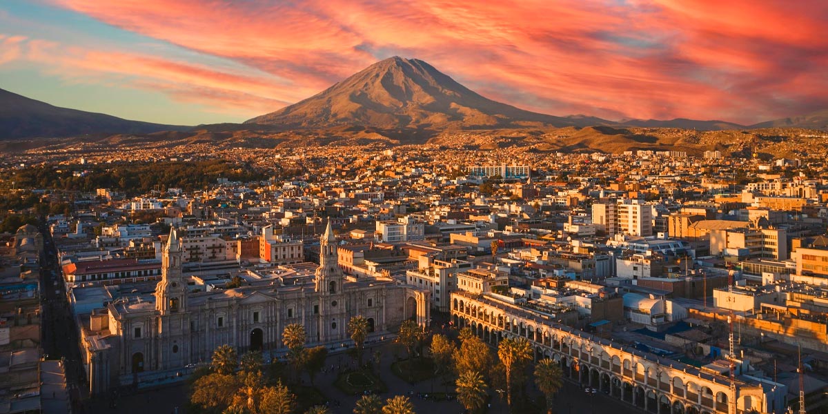
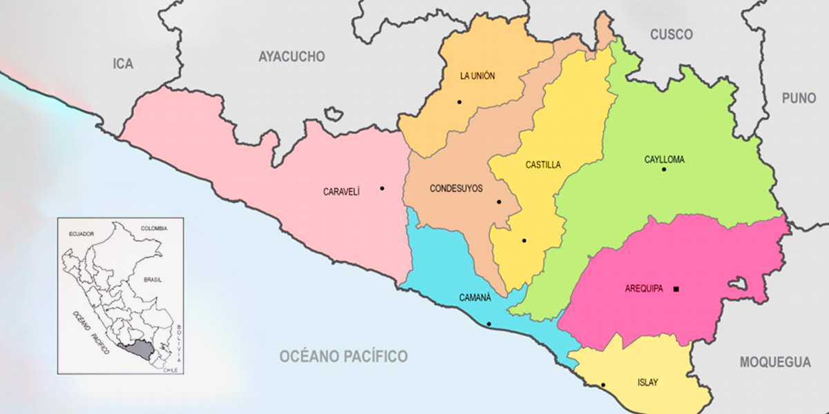
Arequipa is located in the southern part of Peru and is bordered to the north by Cusco, to the east by Puno, and to the south by Moquegua. Arequipa is the second largest city in Peru after Lima. Many buildings around the Plaza de Armas were built with volcanic ashlar from the surrounding volcanoes, giving Arequipa the nickname “The White City”. Earthquakes are also quite common in the region. In the last year, there have been 65 earthquakes with a magnitude of 1.5 or higher on the Richter scale.
Climate in Arequipa
- Dry season
April to December. Very low humidity, no rain, and temperatures that, although practically the same as in summer, can feel a little colder due to the dryness of the air. - Rainy season
January to March. During these months, there is at least a 6% chance of rain on any given day. Be prepared for some cold days, otherwise there is nothing else to worry about.
The best time to visit Arequipa is from early April to early December, with the first few weeks of September having the best weather of those months. It is during this period that you will experience the driest weather and clearest skies. That being said, Arequipa's weather is generally mild and pleasant year-round, so any time of year is ideal to visit the city.
For more detailed information, check out our post on the weather in Arequipa.
How to get to Arequipa?
Being one of the most visited cities in Peru, there are several ways to get there. There are options from bus, flights, and even trains available to the ‘White City’.
Arequipa Facts
- Arequipa was founded in 1540 by Garci Manuel de Carbajal.
- Due to its culture and beauty, Arequipa's Plaza de Armas has been named a UNESCO World Heritage Site.
- Arequipa has a population of approximately 840,000 people.
- It is nicknamed the White City of Peru, due to the white volcanic rock (known as sillar) that was used in the construction of many colonial-era buildings.
Is Arequipa at a high altitude?
Arequipa sits at 2,340 m (7,700 ft), 1,000 m (3,000 ft) lower than Cusco or Puno. Few travelers suffer from altitude sickness here, and visitors can take time to acclimatize if they are coming from sea level.
Arequipa is the perfect intermediate stop after Lima and before heading to higher elevations. Other destinations in the Andes, such as Cusco and Lake Titicaca, are at a much higher altitude. Arequipa sits at 7,700 ft (2,340 m), 3,000 ft (1,000 m) lower than Cusco or Puno. Few travelers experience altitude sickness here, and visitors can take time to acclimatize if they are coming from sea level.
Note that the road between Arequipa and Colca Canyon reaches heights of 4,000 m (13,100 ft). You'll notice the higher elevation if you try any strenuous activities, such as hiking. Chivay and other Colca Canyon towns are at about the same elevation as Cusco, 3,400 m (11,150 ft).
Plaza de Armas: 7,700 ft (2,340 m)
Misti Volcano Summit: 19,101 ft (5,822 m)
Chivay, Colca Canyon: 11,150 ft (3,400 m)
Arequipa to Colca Canyon Highway (Patapampa Pass): 12,000 ft (4,000 m)
Best Tours in Peru
Many are the routes that take you to Machu Picchu, but none is like the Inca Trail Tours, the most famous pedestrian path in the Americas. After flying from the capital of Perú, Lima, you will arrive in Cusco to walk for four days along a path through forests and dense fog, millenary stone steps and discovering the ruins of ancient fortifications and Inca cities, and all the time enjoying majestic views.
- Peru Adventure Holidays
- Enigmatic Peru
- Peru Full of Adventures
- Peru Luxury Travel
- Peruvian Highlands
- Peru Honeymoon Luxury
- Inca Trekkers
Inca Trail, Machu Picchu and more
- 3 Day Inca Trail Tour
- Short Inca Trail
- One Day Hike Royal Inca Trail
- Machu Picchu Day Trip from Cusco
- Machu Picchu Honeymoon
- 5 Day Salkantay to Short Inca Trail
- Lima & Salkantay Trek to Machu Picchu
- Amazon and Machu Picchu Tour
- Manu Adventures Cusco
If you want to visit Machu Picchu, we recommend you to book your Machu Picchu Ticket in advance, so you will enjoy your Vacation in Machu Picchu without any problem.


