
The Rainbow Mountain is a geological formation in the Peruvian Andes whose slopes are colored by stripes of mineral sediments that create a visual effect that seems impossible in nature. It is a few hours from Cusco, at more than 5,000 meters above sea level, and it is not the only one of its kind: the melting of the snow and the mineral wealth of the mountain range have uncovered several mountains with this same condition in the Andean region.
The best-known route, to Vinicunca, has become one of the most sought-after destinations in Peru in recent years. So much so, that on peak days up to 1,000 visitors can reach the same trail. It is a valid experience, but the massive crowding takes away some of its charm. The good news is that there are other alternatives for those who prefer to get away from the crowds and look for a more genuine contact with the landscape, there are two lesser-known options in the Ausangate mountain range that offer equally impressive views with far fewer people:
- Palccoyo — more accessible in terms of physical difficulty, and with the bonus of a river of reddish waters that runs along the way
- Pallay Poncho — a sharper and less traveled peak, for those looking for something more remote
The Cusco region offers three options: Vinicunca for those who want the classic route, Palccoyo Mountain for a calmer and more accessible version, and Pallay Poncho for those who prefer to get out of the circuit completely. Each of these impressive colored mountains has unique characteristics that make them special. Next, we will tell you more about each of them so you can compare them, choose the one that best fits your interests, and plan an unforgettable experience during your trip.
Rainbow Mountain Peru
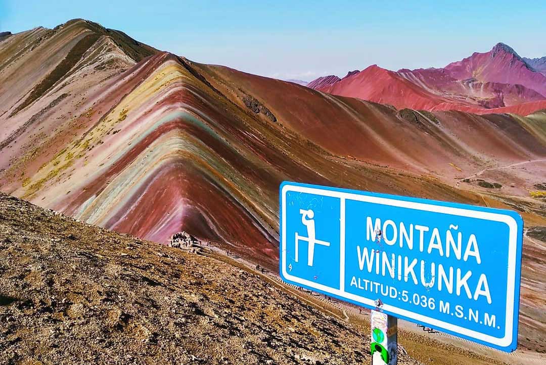
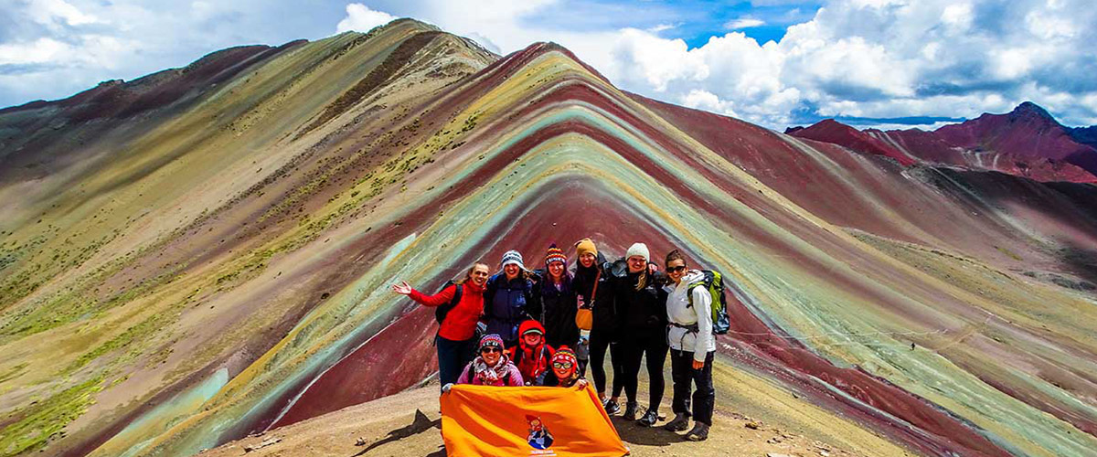
The Rainbow Mountain of Cusco, also known as Vinicunca, has become in a few years one of the most visited destinations in all of Peru. It is located more than 100 kilometers from Cusco, and to reach its highest point you have to climb up to 5,200 meters above sea level. Furthermore, a curious thing is that, until a few years ago, this mountain was completely covered in ice, so its real color remained hidden for a long time.
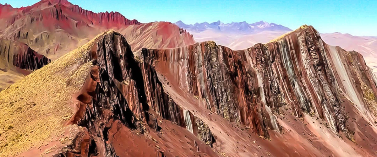
The colors that made it famous are no accident: they are the result of different minerals that were exposed when the ice retreated. In this sense, the red comes from the oxidation of iron, the green tones appear due to the presence of copper and chlorite, the yellow is due to sulfur and limonite, and the purple and pink tones are formed by a mix of feldspar, clay and cinnabar. Consequently, it is basically a geological map painted on the mountain.
Since it went viral on social media in 2016, the number of visitors has grown a lot. Today, up to 1,000 people per day can arrive at the mountain, which makes it a quite crowded place. Therefore, since there are no strict capacity limits yet, the best advice we can give you is to leave Cusco Peru very early, ideally before 4:00 a.m., to arrive before the crowds and enjoy the view with more peace.
To enter the area you need to pay a community ticket, which costs around 30 soles. It is paid in cash directly at the checkpoints at the foot of the mountain, with no need to book in advance. Even so, if you prefer to avoid complications, going with an authorized agency makes the process much easier for you.
Location and Height
The Rainbow Mountain is located right in the heart of the Peruvian Andes, inside the Canchis province, in the Cusco department. Reaching its highest point means climbing up to 5,200 meters above sea level, so the effort is real. Likewise, if you prefer to organize your own route without relying on a tour, the approximate coordinates are 13°52'10"S and 71°18'11"W, useful to locate it on Google Maps or your GPS.
This area belongs to the Pitumarca community, which for generations has known this mountain as "Colored Hill". Consequently, tourism in the area has become a very important source of income for this community, since part of what visitors pay goes directly to the well-being and education of the families who live and care for this area.
Before becoming famous, this mountain was already known among the most experienced travelers, mainly because it is on the way to the imposing Apu Ausangate. However, everything changed in 2016, when it went viral on social media and, overnight, it became one of the most visited destinations in all of Peru.
Palccoyo Mountain
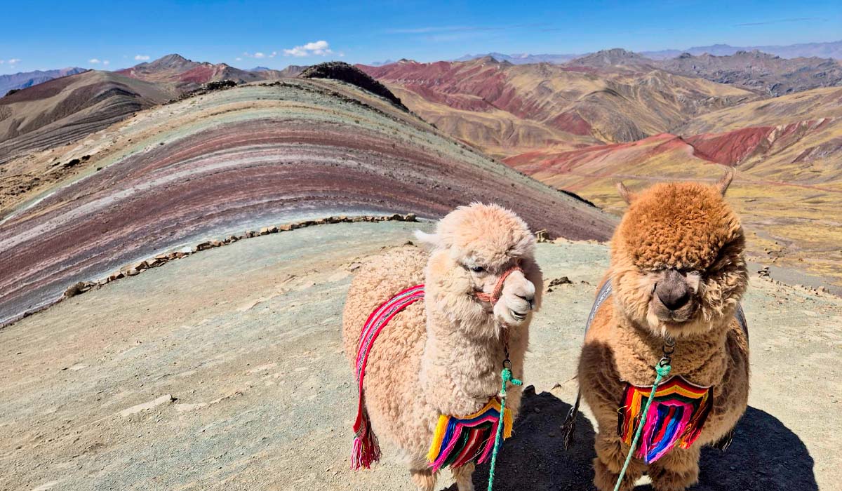
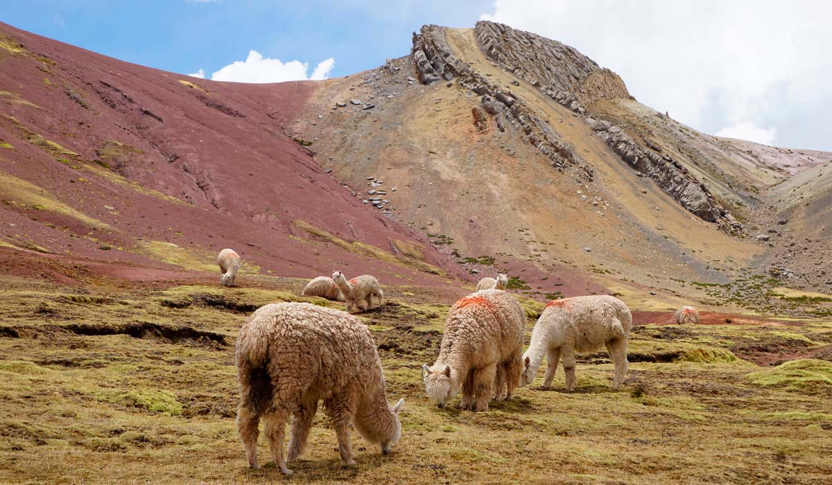
Palccoyo is one of those places that few still know, but that is completely worth visiting. The walk starts to feel demanding above 4,300 meters, where the air becomes thinner, but the effort is quickly rewarded with the landscape. Even if you are well acclimatized, it is best to walk at a calm pace, stopping from time to time to enjoy the view: the reddish-colored earth, small farms, and herds of alpacas, sheep, and llamas grazing next to the road. It is a landscape that invites you to walk slowly.
As you go up, you will reach a narrow ridge with sharp rock formations, and there, finally, appears the reason why so many people come here: the Palccoyo mountain in all its glory, with stripes of mineral colors that contrast with the blue sky and, in the distance, the Red Valley. A few years ago, almost no one knew this place, but more people arrive every time; therefore, if you want to enjoy it in peace, the best thing is to go in the low season or leave Cusco very early in the morning.
Location and altitude of Palccoyo
Palccoyo is located in the Checacupe district, inside the Canchis province. This area is managed by local communities, for whom responsible tourism represents an important source of income.
Regarding the walk, the starting point is at about 4,900 meters above sea level, and the main viewpoint is at 5,000 meters. Unlike Vinicunca, this route is much more accessible: the difficulty is low to moderate, and the walk lasts only between 45 and 60 minutes. The entrance costs 15 soles, a small investment to see one of the most impressive landscapes in the Andes.
Pallay Poncho Mountain
The Pallay Poncho Mountain was discovered relatively recently by the Layo community, and until today it remains one of the least visited and most special colored mountains in the entire Cusco region. Its name has a beautiful meaning: in Quechua, "Pallay Poncho" refers to a traditional hand-woven poncho with complex designs. And the name fits it perfectly, because its slopes show stripes of red, brown, and magenta, with ridges much sharper and more dramatic than those of Vinicunca.
The interesting thing about this route is that it offers two landscapes in one. On the way to the mountain you will pass by the Langui-Layo lagoon, a huge body of water that contrasts beautifully with the colors of the area. However, reaching the summit is not easy: the walk takes between 3 and 4 hours, after a car trip of about 4 hours from Cusco. It is an excursion that requires good physical condition, but that more than rewards the effort.
Location and altitude
Pallay Poncho, also known as Apu Taqllo, is located right on the border between the Canas and Canchis provinces, on the border between the Layo and Ocobamba communities.
To reach the summit you have to climb up to 4,800 meters above sea level. Since it still does not receive the number of visitors that other colored mountains do, this is an excellent option for those looking for something different: a quiet place, less known, but just as spectacular as the most popular destinations in the region.
How to Get There?
Organizing transport from Cusco is one of the most important aspects when planning this excursion. Although technically you can get to any of these mountains using public transport and local vans, this means negotiating tickets directly at the checkpoints and leaving Cusco very early, in total darkness. Therefore, the most recommended option, especially if you do not know the area well, is to go with an organized tour, which saves you time, complications, and gives you more safety on the road.
-
Route 1: Rainbow Mountain (Vinicunca)
To get to Vinicunca, the car trip takes between 3 and 3.5 hours from Cusco. The route passes through the South Highlands Longitudinal Highway until reaching the Pitumarca community, and from there it continues along a mountain road to the town of Pampa Chiri, where the hike begins. From that point, you have to walk (or ride a horse) about 5 kilometers on steep terrain until reaching the summit of the Rainbow Mountain. -
Route 2: Palccoyo Mountain
If your destination is Palccoyo, the car trip takes between 3.5 and 4 hours from Cusco. It follows the same south route to Checacupe, and from there the road turns east, passing by old bridges and quite wild landscapes. The great advantage of this route is that the vehicle leaves you almost at the foot of the mountain, at 4,900 meters high, so you only have to walk between 45 and 60 minutes before reaching the viewpoint with the view of the colored mountain and the red river. -
Route 3: Pallay Poncho Mountain
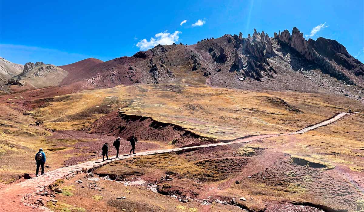
Getting to Pallay Poncho requires the longest trip of the three: at least 4 hours by car from Cusco. The route goes down south to the city of Sicuani, and from there it heads toward the Layo community. From this point, there are several trails that lead to the Apu Taqllo, all with quite steep slopes. That is why it is important not to rush during the climb and, above all, to be accompanied by an experienced guide who knows the safest way to the summit well.
Weather and conditions in the colored mountains
The weather in these mountains is cold all year round, and rain, wind, and altitude sickness are the main challenges to keep in mind. But not all mountains have exactly the same conditions, since the altitude varies among them. Here is a summary of what to expect in each one:
- Vinicunca (the highest)
The walk begins at 4,600 meters and the summit is at 5,200 meters. In the dry season, temperatures go from -5°C to 12°C. In the rainy season, they vary between 2°C and 10°C. - Palccoyo (the most accessible)
Here the base is at 4,900 meters and the summit at 5,000 meters. Being in a more open valley, the weather in the dry season is a bit more bearable, between -2°C and 14°C. In the rainy season, it ranges between 4°C and 11°C. - Pallay Poncho (the newest)
This route starts at 4,700 meters and goes up to 4,800 meters. In the dry season, temperatures go from 0°C to 15°C, and in the rainy season, between 5°C and 12°C.
What is the best time to visit?
The best season to do these tours is during the dry season, from April to October. In these months the chance of rain is very low, the ground stays firm, and the views of the mountains are much clearer.
If your trip falls in the middle of the year, you can take advantage to combine it with the Inti Raymi, the great Inca celebration that takes place every June 24, and then complete your trip with a visit to Palccoyo or Pallay Poncho.
However, keep in mind that, during the coldest months of the Andean winter, especially June and July, the freezing nights can leave the road to Vinicunca covered in ice in the mornings, which makes the trail quite slippery. Therefore, at this time it is important to wear trekking boots with a good anti-slip sole. And if your trip falls in the rainy season (November to March), do not forget to bring good quality waterproof clothing, because you are going to need it.
Flora and Fauna
These mountains, besides their landscape, also shelter life adapted to the extreme conditions of the altitude. During the tour, it is very likely that you will see herds of llamas and alpacas, taken care of by local communities, who also raise horses to support visitors who prefer not to walk the whole way. If you look carefully at the rocky areas, you might be lucky enough to see vizcachas or small groups of vicuñas, those wild camelids that move freely through the cold plains of the area.
Furthermore, in the sky, there is also much to observe. If you pay attention to the air currents around the Ausangate massif, it is possible to see the Andean condor, one of the largest and most impressive birds in the region. At ground level, you can find species like the Andean partridge, known locally as kiula, and in the rivers and streams of the area, torrent ducks usually appear, experts at moving in fast waters.
As for the vegetation, a large part of the landscape is covered with ichu, a resistant grass that serves as the main food for the herds of the area. You will also find the yareta, a compact plant that grows attached to the rocks, forming a kind of cushion that allows it to resist the cold and the wind. And if your route takes you to certain protected areas near the Ausangate, it is possible that you will see the Puya de Raimondi, one of the oldest and most impressive plants in all of the Andes.
Tour of the Mountain of the 7 Colours
Before becoming famous, this mountain was simply a passing point on the long four-day route to the snowy Ausangate. But with all the interest it generated in recent years, today the safest and most practical way to visit it is through an organized tour. Most agencies in Cusco offer 1 or 2-day trips that include transport, food, the corresponding tickets, and a guide throughout the tour. As for the price, these tours usually cost between 30 and 80 dollars per person, depending on the service quality, the group size, and what is included.
Regarding the difficulty, this walk is considered moderate to high. The full tour, counting round trip, takes between 3 and 4 hours, although the time can vary depending on your physical condition. The path does not have technical or dangerous sections, but it does have steep slopes that feel much more demanding due to the cold, the wind, and the lack of oxygen typical of the altitude.
For the experience to go well, here are some practical tips:
- Arrive with time to acclimatize
Stay in Cusco at least 1 or 2 days before the tour, to give your body time to adapt to the altitude. Also, leave the city early, ideally before 4:00 a.m., to reach the summit before it gets crowded with people. - Dress in layers
Bring warm clothing in layers, pants that cut the wind well, and a waterproof poncho on hand in case it rains suddenly, something quite common in this area. - Take care of your feet and your skin
Use trekking boots with a good grip, since the ground can have loose dirt or frost. Also bring glasses with good UV protection, sunscreen, and a warm hat or beanie. - If you get tired, help is available
If you feel that you can no longer keep walking, do not force yourself. In the area, locals usually rent horses, so you can reach the summit without putting your health at risk.
Other Famous Tours in Cusco
Cusco has so many travel options that many times the most interesting thing is to combine several experiences in the same tour. Therefore, if you want to make the most of your trip, here are some popular combinations before moving on to the most traditional routes:
- Rainbow Mountain + Machu Picchu
- Ausangate Trek + Rainbow Mountain
- Rainbow Mountain + 5 day Inca Trail
Furthermore, if what you are looking for is to focus on reaching Machu Picchu through the historical routes, there is nothing that compares to the Inca Trail tours, considered one of the most famous and demanding hikes in all of America. After arriving in Cusco, this adventurous route takes you through cloud forests, stone stairs built by the Incas, and ancient fortresses, all with spectacular views on the way. Consequently, there are several options to choose from, depending on the time you have available:
- Salkantay Trek to Machu Picchu 5 Days
- Hiking the Inca Trail to Machu Picchu 5 Days
- Inca Quarry Trail 4 Days
- 2 Day Inca Trail Tour
- 2 Day Inca Trail with Camping
- 3 Day Inca Trail
- Vilcabamba Hike to Machu Picchu 6 Days
- Choquequirao Trek to Machu Picchu 9 Days
- Ausangate Trek 7 Days
Finally, if your final plan includes visiting Machu Picchu, remember to book your ticket well in advance. It is the only way to make sure everything goes well and to avoid running out of space at the last minute.


