
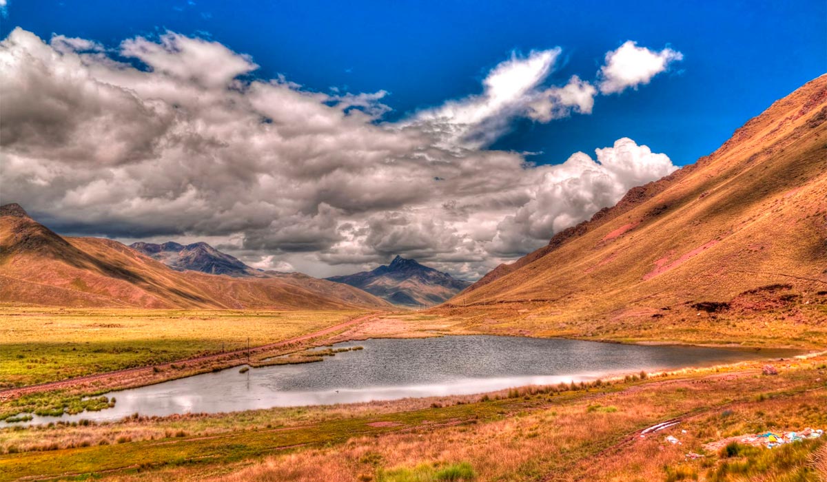
The Abra La Raya is a high mountain pass located in the Peruvian highlands and serves as the natural geographical limit between the departments of Cusco and Puno. Located at 4,338 meters above sea level, this pass is the highest point on the highway and the railway line that connects both cities. Geographically, the area belongs to the Puna ecoregion, characterized by its extreme altitude and its cold, dry climate.
La Raya has a unique geographical importance: it acts as the continental divide in this section of the Andes. It is here where the rivers that feed opposite basins are born: those that go north join the Vilcanota River and, eventually, the Amazon; and those that go south head to Lake Titicaca. This vast and cold high plateau offers one of the most visual landscapes of Peru, dominated by the native flora icchu (Andean straw) and camelid fauna such as alpacas, llamas, and vicuñas.
Due to its altitude and its scenic value, the Abra La Raya is a stop on the tourist route between Cusco and Puno. A visit to this viewpoint is a fundamental part of any adventure tour in Peru that focuses on exploring the Andean high plateau. This guide is designed to provide information about the location, climate, and points of interest of this important mountain pass.
Location of Abra La Raya
Its location is of geopolitical importance, as it marks the territorial division point between the department of Cusco (Canchis Province) and the department of Puno (Melgar Province). The summit is located at 4,338 meters above sea level (14,232 feet), being the highest altitude point of the Southern Interoceanic Highway and of the railway route that connects both cities.
Geographically, La Raya works as the main landmark of the continental divide in this section of the Andes. It is here where the rivers that flow toward two opposite basins are born: the Amazon (to the north) and Lake Titicaca (to the south). Logistically, the pass is a required stop on the Route of the Sun tourist route, where travelers briefly get off to appreciate the Andean altiplano and observe the puna fauna, such as llamas, alpacas, and vicuñas, in their habitat.
La Raya Pass or Abra La Raya
The La Raya Pass (or Abra La Raya) is located at 4,338 meters above sea level, being the highest altitude point on the land and rail route that connects Cusco and Puno. This mountain pass serves as the political boundary between the Cusco and Puno regions, and it is an important marker of Andean geography.
Geographical and Historical Importance
La Raya has key geographical importance: it acts as the continental divide in this section of the Andes. From there, the meltwaters feed two distinct basins: the rivers that flow north give rise to the Vilcanota (the sacred river of the Incas), which heads to the Amazon; and those that flow south head to the endorheic basin of Lake Titicaca.
Historically, the pass marked the border between the Inca province of Chinchaysuyo (Cusco) and the vast region of Qollasuyo (the altiplano). This route was part of the Qhapaq Ñan road network, used for the trade of products and for the deployment of armies during the Inca expansion towards the altiplano.
Economy and Tourist Context
The pass is located in the Puna ecosystem, a cold environment where agriculture is limited. The main means of living for the local communities is the raising of South American camelids (llamas, alpacas, and vicuñas). Currently, the pass is a required stop for the Cusco to Puno tourist bus, and local artisans take advantage of this flow to sell alpaca and wool products.
The Apu Chimboya
At this point that deserves respect, where the steps become slow and breathing becomes difficult, the artisans of the area converge, to offer their work under the protective mantle of the APU Chimboya (sacred mountain in the Andean cosmogony).
APU is a Quechua word that contains two meanings: Mountain and God, it is for this reason that the Inkas and local people believe until today that mountains are gods and their spirits protect the community.
I believe it too and that is why I pay tribute to my APU Chimboya, I greet him and I thank him for taking care of our trip.
The experience of stopping and descending in the place, is worth by itself. The landscape is imposing, as you contemplate, the sensation of cold or lack of oxygen fade into images of peace and tranquility. The view of the mighty APU is only worth a quiet pause.
It's great when a place so fills the heart with such a colorful gift of color and nature. To give it greater value, the loom work of the artisans in the area leaves you pensive, questioning your pocket because you were determined not to buy anything, but what you see makes you want to give in.

Other Famous Tours in Cusco
There are many routes taking you to Machu Picchu. But none is like the Inca Trail Tours - the most famous pedestrian path of the Americas! After flying from the capital of Peru - Lima, you arrive in Cusco to walk for 4 days following a trail through forests and dense fog, millenary stone steps while discovering the ruins of ancient fortifications and Inca towns. All the time, you might enjoy majestic views. You can pick from the following options:
- Salkantay Trek to Machu Picchu 5 Days
- Hiking the Inca Trail to Machu Picchu 5 Days
- Inca Quarry Trail 4 Days
- 2 Day Inca Trail Tour
- 2 Day Inca Trail with Camping
- 3 Day Inca Trail
- Vilcabamba Hike to Machu Picchu 6 Days
- Choquequirao Trek to Machu Picchu 9 Days
- Ausangate Trek 7 Days
If you like to visit Machu Picchu, we recommend you to book your Machu Picchu Ticket in advance. In this way, you will enjoy your Vacation in Machu Picchu without any problem.


