
Inca Gods
29 November 2021

The Sacred Valley of the Incas is a valley of the Urubamba River. The valley starts 15 km north of Cusco city and stretches about 100 km between two then important Incan cities – the Cusco City and Machu Picchu citadel. The place had a special meaning to the Incas as the sacred river of Urubamba represented a reflection of the cosmic Milky Way in their mythology.
The Urubamba River originates in mountains of the Puno region and its upstream is called Willkanuta, which means the “House of the Sun” in Aymara native language, it was later hispanized to Vilcanota. The river then flows north-west for 724 km and it changes its name to Urubamba in the Convencion province. Sometimes, you can also hear the river is called Willcamayu which is its Quechua name.
The valley was highly appreciated by the Incas also because of its geographical and weather qualities. It was one of the main production places because of fertility of its soil. The valley is a place where the best Peruvian corn is cultivated!
The Sacred Valley possesses an idyllic atmosphere inviting everybody to visit it and stay there. There can found several excellent Incan archaeological complexes such as Pisaq, Ollantaytambo ruins, Chinchero or Moray as well as nearby pre-Incan salt mines of Salineras, etc.
Also, there are numerous marvelous colonial villages, many of them have been involved in rural and experience tourism projects offering visitors quite different experience.
The valley was a personal possession of the Inca's rulers!
Is located 33 km northwest of Cusco. There can be found two attractions: the Incan citadel and the colonial town with its traditional handicraft market. The authentic Incan city is seated on a precipitous mountain above the current Pisac town. This impressive citadel extends to 4 kilometers. The citadel involves ceremonial (spiritual) centre with Inti Watana (Sun Clock), temples showing perfect stone masonry, several water canals, ceremonial baths, military zone, residential zone as well as loads of Inca´s tombs placed in holes on a cliff. The entire citadel is surrounded by agricultural terraces placed on steep slopes.
Is a lovely city and an unofficial capital of the Sacred Valley. Urubamba abounds with lovely weather which is the warmest of the entire valley. The city is also rich in many lovely tourist restaurants offering buffet lunch consisting of typical Andean cuisine.
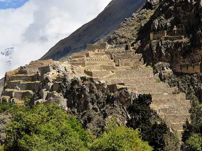
Is the last still alive Incan town! The town has been continuously populated for over 700 years. Its streets are paved with cobblestones and you can see many authentic water channels all across the town. The biggest highlight of the town is its Incan complex that served once as a temple as well as a fortress. The complex is surrounded by precipitous terraces that had also a protecting purpose. On the top of the complex, a ceremonial area can be found, which represents an amazing example of Inca´s architecture. The ceremonial area involves three really huge stones that perfectly fit to each other. The complex witnessed one of the most important battles when Spanish conquistadors were defeated by the Incan ruler Manco Inca.
Is a small town just 28 km far away from Cusco. It is surrounded by the snowy peaks of Salkantay, Soray and Veronica. There can be found ruins of the palace of Tupac Yupanqui (an Inca's ruler) destroyed by Spaniards in 1607 to be built a colonial church called "Iglesia de Nuestra Señora de Monserrat" on its top in order to demonstrate their dominance. This entire site is surrounded by many Incan agricultural terraces. Chinchero can also pride in beautiful and fine weaved textiles having typical designs of the site. The textiles as well as other handicraft can be found in their daily typical market.
Is an archaeological site 50 kilometres northwest of Cuzco and just a short distance west of the village of Maras. This is a very extraordinary Inka's site consisting of many huge terraces formed by circular depressions. The largest of them is around 30 metres deep. The purpose of these depressions was to create different temperatures that enabled to the Incas to study effects of different climatic conditions on crops and after that, its cultivation. For that reason, Moray is considered to be an Inca´s agricultural experimental site as well as a prototype of the first greenhouse. Moray has got a complicated irrigation system too.
Are salt mines that have been used since pre-Inca times. Salt comes from a subterranean salty mineral stream that springs on a hill above the salt mines. The flow of the stream runs into a complicated system of tiny canals that irrigate a huge number of small salty pools. There are about 3,000 salty pools. Apart of that, the salt mines offer overwhelming view when seeing from above access road.
 |
 |
 |
Machu Picchu is one of the wonders of the world and one of the most amazing places on the planet, but it is only one of the many sites that the Incas built.
The Sacred Valley offers a more authentic vision of the ancient Inca civilization and what they were able to build in places like Pisac, Ollantaytambo, Moray.
If you visit Machu Picchu, without visiting at least the best places in the Sacred Valley, you will be missing half of the history. Machu Picchu is the jewel of the Inca empire, hidden among the mountains, and the only way to reach it was to travel an Inca road through the Sacred Valley of the Incas.
Here we show you how to plan a trip that includes Cusco, Sacred Valley and Machu Picchu, and you can fully enjoy your stay.
The days needed to tour Cusco, the Sacred Valley and Machu Picchu are 4, although it can be done in up to 3 days.
The best way to visit places like the ones you will see in Machu Picchu and the Sacred Valley of the Incas is with patience, since the best that the Incas did in their cities, and in a more subtle way, in the constructions made in the new cities founded by the Spaniards, are the details.
Here is a Map of Cusco and Sacred Valley that will help you plan your trip to these incredible destinations.
The Sacred Valley offers all kinds of experiences for visitors.
The incredible geography of the place is the scene of a diversity of adventure sports such as mountain biking, boating on the Urubamba River, hiking through the snow-capped valleys, zipline or canopy from the mountain peaks and much more.
If you plan to know only the valley, the most common tours are 1 day and tour the main tourist attractions of Pisac, Ollantaytambo and Chinchero.
There are tours that include visits to these two places in 2 days.
If you want to make your visit in a single day and on your own; Ideally, start with Pisac. Then meet Urubamba and finally Ollantaytambo.
On another day you can meet Chinchero, Moray and the salt mines of Maras.
The entrance to the archaeological sites is included in the Tourist Ticket of Cusco. The reference cost is 70 soles ($ 23). You can buy the partial tourist ticket, if you only want to visit the sites of the Sacred Valley. Private or public transport is not difficult to obtain.
Many are the routes that take you to Machu Picchu, but none is like the Inca Trail Tours, the most famous pedestrian path in the Americas. After flying from the capital of Perú, Lima, you will arrive in Cusco to walk for four days along a path through forests and dense fog, millenary stone steps and discovering the ruins of ancient fortifications and Inca cities, and all the time enjoying majestic views.
Salkantay Trek to Machu Picchu 5 days
If you want to visit Machu Picchu, we recommend you to book your Machu Picchu Ticket in advance, so you will enjoy your Vacation in Machu Picchu without any problem.
Buses to tour the Sacred Valley, can be taken on "Pavitos Street" or "Puputi Street" in Cusco.
Getting to Pisac by bus will take 45 minutes to an hour and costs approximately S / 7 (US $ 2). From Pisac, you can go to Urubamba in 30 minutes, or to Ollantaytambo in an hour; Prices vary between 5 and 10 soles (US $ 2 - US $ 4).
You can also arrive directly from Cusco to Urubamba. The trip takes about an hour and a half and costs S / 6 (US $ 2). From Urubamba you can visit the villages of Maras, Moray and Yucay, all are just minutes away from this city; Then you can continue to Ollantaytambo (30 minutes).
Collectives are a popular and profitable way to reach the Sacred Valley. This service can cost between 15 and 20 soles per person (US $ 5 - US $ 7).
You can find the buses at various points in the city of Cusco: in Pavitos Street, in the main square of Ollantaytambo (return), and on the way to Cusco - Pisac.
Taxis are the fastest and most convenient way to reach the Sacred Valley; They cost between S /. 60 and 120 soles (US $ 20 - US $ 40) depending on where you want to go.
Pisac is one of the most recommended villages due to the traditions that its people retain.
Buses and minivans go from Cusco to Pisac throughout the day; these leave Puputi Street 15 minutes from the Plaza de Armas of Cusco. It will take around 45 minutes to reach Pisac and the tickets will cost S /. 7 (US $ 2).
In Pisac you will find buses to other places in the Sacred Valley of the Incas.
A taxi from the city of Cusco to Pisac can cost you between S / 50 and 80 soles (US $ 15 and US $ 25).
If you take a shared (collective) taxi, it could cost you around S / 10 (US $ 3) per person; You can find these cars near the bus terminal, on Puputi Street.
Ollantaytambo was a ceremonial center during the time of the Incas. This historic place served as a checkpoint for people who toured the Sacred Valley of the Incas. The town of Ollantaytambo retains its Inca urban organization.
To travel with this last route, you must board the small buses on Pavitos street in Cusco. Buses leave every 15 minutes towards Ollantaytambo.
Bus tickets cost around S / 15 soles (US $ 5). And they are the cheapest way to travel through the valley.
Once in Cusco, you will have to get up very early and go to Pavitos Street, here you will find minibuses and minivans that will charge you around S / 15 (US $ 4)
From Ollantaytambo to Machu Picchu it is even easier. When you arrive in Ollantaytambo, you can take a “moto-taxi”, it is very fun and the easiest way to get to Ollantaytambo station, this will cost you between S / 2 and S / 5 soles (US $ 0.70 and US $ 1.50).
The train journey takes approximately 2 hours (30.5 kilometers away). The final whereabouts is the town of Aguas Calientes.
In Aguas Calientes (also called Machu Picchu town) the buses leave in 30 minutes to ascend a steep mountain to the entrance door to the Wonder of the World (9 kilometers away).
There are other more spectacular routes that take you to know Machu Picchu from Cusco.
Only 15 kilometers from Ollantaytambo is the ‘Km 82’, the starting point of the famous Inca Trail. This adventure travels 40 km, takes Machu Picchu in 4 days and 3 nights.
It is considered one of the 5 best hiking trails in the world, thanks to its trails full of lush fauna and flora; It is also the only way to reach the Inca and pre-Inca buildings it houses.
Tickets must be booked online and months in advance. We recommend doing it 8 months before, and 12 if you want to visit during the high season (May - August).
Is there an alternative way to enter Machu Picchu? This route is much cheaper and is the favorite of young people, being loaded with adventure.
This alternative route offers you many freedoms on your way to Machu Picchu. Mix buses, walks and beautiful landscapes, before reaching the town of Aguas Calientes, at the foot of Machu Picchu.
The Salkantay trek, considered among the 10 best in the world.
This hiking route of 5 days and 4 nights (approximately 70 kilometers) through the imposing snowy Salkantay and then reach the Wonder of the World.
The route crosses even more impressive landscapes than the Inca Trail. You also visit sites such as the beautiful Mollepata Valley, Llactapata ruins and tropical territories where flora and fauna abound.
We always recommend knowing Machu Picchu and the Sacred Valley in 2 days:
Day 1: Tour to the Sacred Valley of the Incas
In Cusco you can take a walk through the Sacred Valley of the Incas and get to know Pisac, Urubamba, Maras, Moray and Ollantaytambo.
After the tour you can take the train directly in the town of Ollantaytambo. The train journey ends in the town of Aguas Calientes, at the foot of Machu Picchu, here the tourist can spend the night in a hotel in Aguas Calientes (Machu Picchu town).
Another option is to know the tourist attractions of the city of Cusco: Sacsayhuamán, Coricancha, the Plaza de Armas, the museums of the city, etc.
Day 2: Machu Picchu Tour
The second day will be exclusive to know the Inca City of Machu Picchu.
In Aguas Calientes you must take a bus (30-minute trip) to the entrance door to Machu Picchu.
The tour of Machu Picchu is in the company of a tour guide (you can get one at the entrance door) and lasts a maximum of 4 hours.
In Machu Picchu the visitor will be able to appreciate the more than 150 constructions such as: the Temple of the Sun, the Intihuatana, the Temple of the Condor, the Main Square, etc.
Once you return to the town of Aguas Calientes, you can take some time to eat something before starting the return to your hotel in the city of Cusco or the Sacred Valley.
To get to Machu Picchu by train you must book tickets online in advance. It is recommended to do so immediately after knowing the date of visit to the Wonder of the World.
Once in the city of Cusco (Peru), the visitor should approach the chosen train station (Poroy, Urubamba or Ollantaytambo station). It is advisable to be 30 minutes before the scheduled travel time.
All train services have as their final destination, the town of Aguas Calientes (Machu Picchu town). From there, you only have to board one of the buses that take you to the Machu Picchu gate in approximately 30 minutes.
There are 3 boarding stations for outbound trains. There is only one station to board the return train.
In most cases, you will board your train to Machu Picchu at Ollantaytambo station. Poroy station is restricted by security during the rainy season (from November to March).
Ollantaytambo Station: Av. Ferrocarril s / n, Ollantaytambo, Sacred Valley (Cusco).
Poroy Station: Roldan Street s / n, Poroy District, Cusco.
Urubamba Station: Av. Ferrocarril s / n, Urubamba, Sacred Valley (Cusco).
Return train stations:
Aguas Calientes Station: Machu Picchu Pueblo, s / n, Barrio Las Orquídeas (next to the Mercado de Artesanos de Aguas Calientes).
The duration of the trip by train (one way) depends on the station where the train is boarded:
The distance from Poroy (Cusco) station to Aguas Calientes is approximately 65.8 kilometers. The tour crosses the beautiful landscapes of the Sacred Valley of the Incas. The trip takes approximately 3 hours and 15 minutes.
The distance from Urubamba to Aguas Calientes is 47.6 kilometers. The route is parallel to the Vilcanota river and the mountains. The trip takes approximately 2 hours and 30 minutes.
The distance from Ollantaytambo station to Aguas Calientes is approximately 30.5 kilometers. The train runs through the beautiful and green Sacred Valley of the Incas along the banks of the Urubamba River. The trip takes a little less than 2 hours.
The entrance ticket to Machu Picchu only allows access to the Inca city and all attractions. Guidance is an annex service that is contracted separately.
According to the new rules that govern and regulate access to Machu Picchu, it is necessary to take the services of a guide to enter it; It can be through a private service or as part of a group.
You can hire a guide at the entrance to Machu Picchu, the guides offer shared tours from 30 soles per person (approximately 10 dollars). The tour guides are in charge of a group consisting of a maximum of 16 tourists.
The guiding time lasts approximately two hours, you can stay for 4 hours from the moment you enter.
There are 3 circuits to perform in Machu Picchu.
Circuit 1 is the longest and takes approximately 3 hours. Circuit 2 is the most used and takes approximately 2 hours 30 minutes. Finally there is circuit 3 that lasts 2 hours and is special for older adults and people with disabilities.
All tours include a visit to the main temples and precincts of Machu Picchu, such as: the Temple of the Condor, Main Square, the Botanical Garden, the Guardian's House and more.
The best season is during the dry season, which covers the months April to the end of September. In October the rains begin and you can find Machu Picchu covered by clouds. If you travel in June, we recommend you to book the Inti Raymi 2020 Tour that takes place in June 24th, and also hike the Palcoyo Mountain Tour, which is an incredible Rainbow Mountain located in the Andes.
Tierras Vivas Travel offers the best all-inclusive Inca Trail to Machu Picchu tours in Peru.


